


Cayman Islands | Your local guide to the Cayman Islands
The Cayman Islands are a leading offshore financial hub known for tax advantages and investment opportunities
Advanced healthcare system, excellent and world-class facilities, caters to locals and medical tourists, well-equipped hospitals.
Cayman Islands is a British Overseas Territory in the Caribbean known for offshore finance, tourism, crystal-clear waters, and diverse marine life
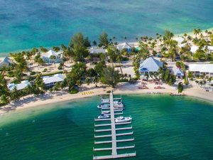
A leisure guide to the Cayman Islands, enjoy sun-soaked beaches, crystal-clear waters, a vibrant culture and more…
Snorkel at Stingray City, explore Seven Mile Beach, visit Cayman Turtle Centre, dive the Kittiwake wreck, and savor seafood cuisine
Home » Information » Geography
The Cayman Islands are three islands, Grand Cayman, Cayman Brac and Little Cayman, located in the Caribbean Sea.
With a latitude between 19 degrees 15 minutes and 19 degrees 45 minutes North, and a longitude between 79 degrees 44 minutes and 81 degrees 27 minutes West, they are well within the tropical zone. Grand Cayman is about 150 miles south of Cuba and 180 miles west of Jamaica. The three islands are outcrops of the Cayman Ridge, a range of submarine mountains extending west-southwest from the Sierra Maestra range in the southeast portion of Cuba to the Misteriosa Bank in the direction of Belize.
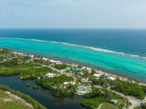
The Cayman Trough lies between the Cayman Islands and Jamaica. It is the deepest part of the Caribbean, being over four miles deep. South, towards the Gulf of Honduras, is the Barlett Deep. These deep areas of ocean are in close proximity to the three islands. This, combined with the fact that Grand Cayman and Little Cayman are almost surrounded by living coral reefs, provide the Cayman Islands with some of the most magnificent dive sites in the world. There is no possibility of a fishing industry, however, because apart from the Cayman Bank, a five-mile by half-a-mile area some ten miles west of Grand Cayman which lies at 15 to 20 fathoms, there is no continental shelf.
Sponsored Ad
The total area of the three islands is about 100 square miles. Grand Cayman is about 76 square miles, Cayman Brac, 14 square miles and Little Cayman, 10 square miles.
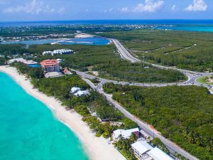
Grand Cayman is approximately 22 miles long and 8 miles at the widest point wide. The highest elevation is about 60 feet above sea level and the most striking topographical feature is the North Sound, a shallow reef-protected lagoon with an area of about 35 square miles.
Cayman Brac lies about 90 miles east northeast of Grand Cayman. It is about 12 miles long and a little over a mile wide. The Bluff is the Brac’s most outstanding feature, rising along the length of the island and reaching a height of 140 feet at the eastern end then falling in a sheer cliff to the sea.
Little Cayman is five miles west of Cayman Brac and is ten miles long and two miles at its widest point. It is the flattest of the three islands with its highest elevation being 40 feet. To the west, a five mile channel separates Cayman Brac from Little Cayman.
The three islands are formed of two distinct formations of calcareous rock. The older limestone, called bluff limestone, was formed in the Oligocene-Miocene period, about 30 million years ago. This limestone forms the central core of each island. It is a dense karst limestone. Surrounding this bluff limestone core is a coastal limestone terrace called “ironshore”. Ironshore is a formation of consolidated coral, mollusk shells and marl with some limestone. It was formed about 120,000 years ago in the Pleistocene period. The Pleistocene period was marked by a series of ice ages. After the last ice age, the sea level began to rise slowly from a level about 400 feet below present sea level.
All the islands lack rivers or streams because of the porous nature of the rock and the absence of hills or valleys. The lack of water and sediment runoff into the sea gives the islands the amazing clarity of water around them. In the rock are many cracks and fissures. Soil is found mainly in pockets, though there is arable land, noticeably on top of the Bluff on Cayman Brac.
Sponsored Ad